In the discussion about added height under HOMA, I’ve written a bit previously, but since the pedestrian core concept was recently misunderstood at a candidate forum, I’d like to clarify what I’m envisioning.
When neighbors of one of the larger upzone spots (which currently has surface parking that separates the arterial from the covered pedestrian walkway at the front of the shops) questioned whether the changes would be “neighborhood-serving” with all the adjacent parking removed, it made me imagine the experience of walking from shop to shop.
As a pedestrian, I do not think it is relaxing or desirable for the sidewalk to be sandwiched between the building and an arterial road with a fast stream of cars. While “shopping streets” can have storefronts adjacent to the sidewalk, these are usually much smaller, with fewer cars that are traveling slower and conditions that permit jay-walking safely. Sidewalks around the outside of a block also make sense if they are part of a street grid, whereas HOMA seems to be proposing many isolated upzones.
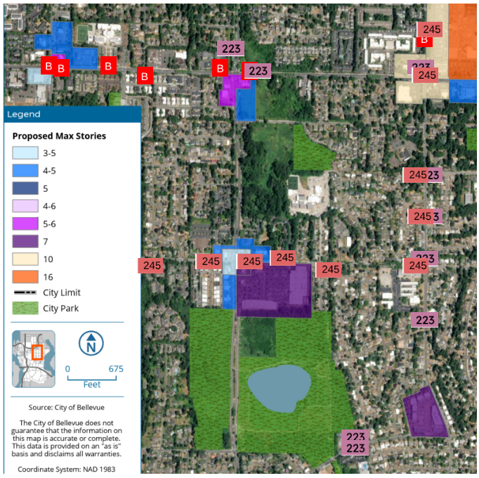
Here is a snippet of the map for Crossroads to show how scattered some of the additional height is; the bus stop locations were added by me. As a side note, the blue parcel at the top center appears to be wetland/stream, so I’m not sure if all the possible upzones are final.
In a letter to Planning Commission (Written Communications, page 6), I said we should start by designing this from the perspective of a transit user, with the goal that transit riders have an experience that’s just as nice as people who drive. There should be enough room along the arterial side of the parcel for a bus stop to be provided, and the project should deed land for the pull-out to the city if necessary so that traffic along the street isn’t impeded. We should combine bus location monitoring technology with signage that uses green/yellow/red lights to let rideshares, Metro Flex, and other drop-off drivers know when they can also use this curb space.
This bus stop node should then lead to the pedestrian core of the facility. The pedestrian core could be oriented about 90 degrees from the arterial road it fronts, and the idea is that this would have shops on both sides (or shops on one side and the residential building on the other) and no cars whizzing by. The HOMA process is considering minimum amounts of ground-level space for stores, residential lobbies, etc., which are referred to as active uses. It is important that these active uses don’t have to have “street frontage” to be counted, and ideally they’d actually get extra credit if not pushed up against the arterial.
The Planning Commission could define a minimum pathway width based on site size, probably 14-20′ if open-air and 10’ wide if enclosed. It would probably be designed slightly wider at the mouth, since you might give “open space” a higher score if it is placed along this pedestrian core. If there is a grocery store on-site, a cart corral should be located as conveniently to the bus stop as possible.
Parking access and/or at-grade parking* could go on the sides of the parcel, ideally functionally increasing the setback to neighboring residences over the 25’ that’s currently proposed** and increasing the odds that trees*** are retained along the edges.
I noticed that the summary from The Urbanist also left out my support for a No Surprises Act for renters within Bellevue and only covered a sliver of the east-west transportation picture. Here is one element that I’m optimistic will help. I also hope we can explore whether it’s possible to slightly reduce the developer’s obligation to create space for active uses in exchange for a program that will help small businesses by ensuring that the space that *is* being built is more likely to get rented out rather than sitting empty.
I hope that by writing this, I will encourage other people to make variations that make sense for different locations, using scenarios to highlight both design goals and things we’d like to avoid if possible. I expect we could spend more time thinking about how this will intersect with legislation around things like parking and corner stores too.
*In the HOMA economic analysis, lowrise development was the only housing type with favorable market conditions that allow feasibility. Positive conditions for lowrise development were almost entirely be attributed to its utilization of surface parking rather than structured parking. A major change in the proposed rules is an alteration in lot coverage that would disincentivize surface parking but still allow density. It is interesting to see in the analysis how parking spot construction costs increase with depth. In a prototypical 250 unit building, the Middle Housing changes reduced the parking requirement from 338 to 250 spaces, and a further decrease will come soon with ESSB 5184 implementation. (See meeting materials for October 8th PC meeting)
**HOMA proposes an additional 15-foot upper-level stepback for any building facade over 80 feet tall that are within 50 feet of a residential district. The planning commissioner questioned why the wedding cake concept is not being applied to mixed-use areas outside of Downtown. Staff said there’s only enough room for this in some placeslike Crossroads and Factoria.
***Trees are likely to be found on the edges of these parcels since Bellevue has had a Transition Areas standard that historically increased setbacks between mixed use structures and houses. With the removal of Transition Area protections, it seems obvious that the vast majority of trees would be removed to facilitate construction, since the work area will overlap with the tree’s root protection zone(s) that is defined as a circle whose radius is based on tree diameter. The Tree Code was also significantly weakened under Council’s June 2025 vote, with the tree viability provision, so there is less incentive to retain the bigger trees.
[11/23/25] There is a comment on page 16 of the Sign Code engagement summary that reads: “As a mixed use developer we struggle with the requirement to have an exterior entrance directly off the street in order to receive signage allotment. Sometimes an exterior entrance does not benefit the operations or layout of restaurants or shops located on the street level. We think allowing tenants that have a facade that faces a street at street level should be allowed one sign at a minimum. We know that not every tenant would utilize this allotment if they had it but it creates better opportunities for tenants that do.”
Leave a Reply