Tag: map

  • How far might people walk to reach transit?

    Update: Clarification was provided in the agenda memo for the April 23rd Planning Commission meeting (see page 4), showing that the walking distance will be used instead of the radius. There are still some details which might need clarification, as laid out in the “Three Requests for the Planning Commission” post.

    Since Bellevue is proposing to allow up to 9 middle +2 ADUs or a co-housing/SRO building within a 0.5 mile radius of RapidRide and Link, here are some examples of what the actual walking distance might be:

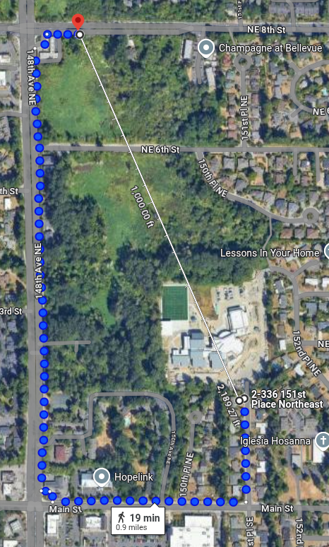
    This location is 0.9 miles from an existing RapidRide B stop.

    (more…)
  • Spatial differences between HB 1110 and Bellevue’s proposal

    The current areas in which bonus density is being proposed for Bellevue are:

    • Within 1/4 mile of Neighborhood Centers and Regional Growth Centers
    • Within 1/4 mile radius of frequent bus service stops
    • Within 1/2 mile radius of “Major Transit” like RapidRide and East Link

    Based on the state law, the only place with bonus density would be:

    • Within 1/4 mile walking distance of Major Transit

    These are moving targets, because there will be new “Frequent” bus lines as part of the East Link Connections project. Based on the Bellevue Middle Housing LUCA draft definition of frequent bus service (“A stop that receives transit service at least four times per hour for twelve or more hours per day.”), there will be frequent service on the 220, 240, 245, 250, 270  plus Sound Transit Express 550, starting sometime this year. The maps shown by the city in the public meetings about middle housing show only the bus lines that are providing frequent service now.

    (more…)