Updated with WFDW quote and an application example:
TLDR: Please consider writing in to the Planning Commission either by 11am on Tuesday (in order to be included in their Written Communications pdf that’s sent out a week before the September 24th meeting) or prior to the meeting (though I’m not sure how far in advance you have to comment for them to see it).
One of the things that had been expected to moderate the impacts of the recent middle housing upzone that passed in June 2025 is the “development intensity factor” that would reduce the potential number of housing units in proportion to the percentage of the site that’s a critical area. Unfortunately, the current version of the Critical Areas Ordinance update would eliminate this factor.
(link to ppt)
A density factor like this is a common feature in other cities’ codes too. For instance, Seattle’s wording says: “Density on lots with Environmentally Critical Areas (ECAs) would be reduced in portion to percentage of lot that contains ECAs” This means that if your lot is 50% wetland, you can build 50% as many housing units.
Is the state legislature requiring us to make this change? No, HB 1110 density does not apply to parcels with critical areas (wording was refined in HB 2321 to specify portion of a lot).
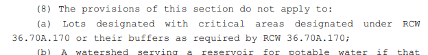
HB 1110 also does not prevent us from increasing our environmental protections.
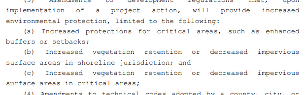
The Model Ordinance under HB 1110 would actually have included the following wording for critical areas (see Page 9).
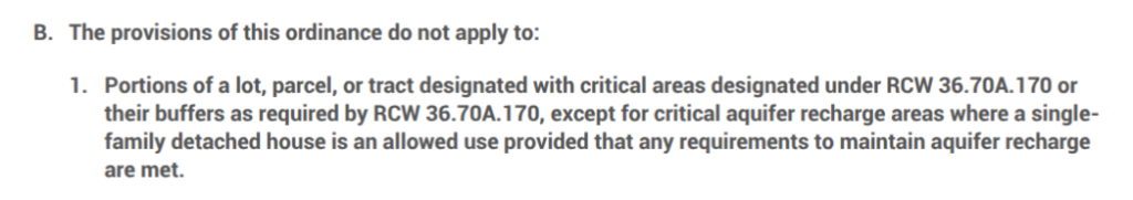
Unfortunately, Bellevue’s current draft would just eliminate this part of the code.
The proposed changes to Bellevue’s Critical Areas Ordinance would eliminate this part of our code entirely, effectively upzoning just the parts of Bellevue where there are streams, steep slopes, wetlands, floodplains, and priority habitat areas. While it would still not be possible to put structures on those critical areas directly, the portion of the parcel not covered by critical areas would then be able to use the higher unit count to get a greater FAR and potentially a larger structure size (caveats below).
(From Page 33 of the enactment)
It’s not clear how an allowance for four units plus two large ADUs plus two fee-in-lieu units would have been handled without this change to the CAO. It’s possible that a lot that is 50% critical area would have been eligible for two units plus 0, 1, or 2 ADUs and able to pay for 0, 1 or 2 extra fee-in-lieu units.
Since the process of passing the Middle Housing LUCA was very hurried, the FAR numbers were all raised partway through the process and never lowered when the building height maximums for middle housing were reduced by 6 feet. This means you have to do some test scenarios* to see what the impacts really are. It might be hard to use all the allowed FAR even with the reduced setbacks allowed for middle housing.
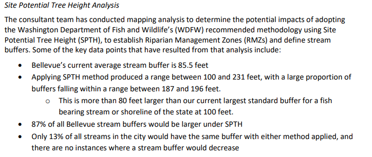
Adding this much density close to streams seems likely to increase parking cars and trucks in places where the runoff goes straight to the stream. It means more clear-cutting of areas just outside the stream buffer critical areas (I think the stream buffers might actually be decreasing since they previously would have been measured from the top of bank – see page 48) whereas if we were following the Best Available Science for stream buffers with the SPTH methodology (below), we would significantly widen the stream buffers.
(Link to agenda memo from 7/23/25 Planning Commission meeting)
You can see some excellent expert comments in the Written Communications document from the meeting on September 10th; this compilation of letters is attached to the agenda for each month’s meeting. I thought it was interesting to see the advocacy for allowing the buildable potential for BelRed to be larger, vs. creating setbacks for the underground streams to allow future work and maintenance on them. It was also pointed out that we need to make sure we don’t create incentives to put streams underground that are currently at the surface, and that we need to protect corridors for wildlife.
There’s also a letter from WDFW that was included in the 7/23/25 meeting’s Written Communications; on page 14 of the packet, it has this to say about 20.25H.045:
“This section discourages overutilization of land by limiting how much development credit is granted for constrained areas. If removed (as
currently proposed in this draft), there may be pressure to grant full density on sites where a large portion is composed of critical areas.
Without this section, there’s a risk that applicants will seek to apply base zoning densities to entire parcel areas, including wetlands and buffers, which should be excluded or discounted due to their ecological constraints. Removing density allocation provisions from the
CAO could open the door to overdevelopment in locations where critical areas severely limit actual buildable area. It also weakens the tools
planners use to balance growth with ecological integrity.”
Please don’t feel that you need a doctorate to write a letter about what you think is important; also, it can be short! I hope people will write in to advocate for keeping the density factor section, using the SPTH method to establish riparian zones, and contribute any thoughtful ideas they may have about balancing growth and important habitat. I would like to point out that now that we’ve allowed 8 units per lot on every single family lot in Bellevue, it may not be necessary to selectively upzone in the vicinity of streams and wetlands.
Write to PlanningCommission@bellevuewa.gov
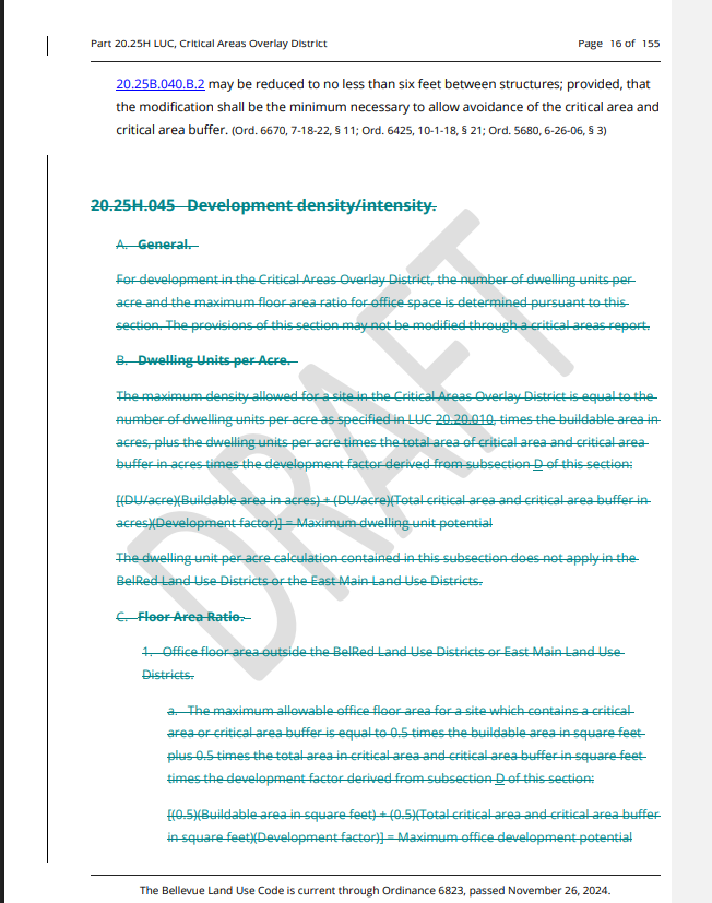
*For an example bordering a critical area, I’m assuming that lot is 20k sqft and has 2 units plus an attached ADU and one fee-in-lieu unit. It could have an FAR of 0.6 for those three non-ADU units, and the FAR goes up to 0.9 if there are six non-ADU units allowed. This is the difference between being able to build 12,000 sqft of structure plus 900 sqft of garage/unheated storage and being able to build 18,000 sqft plus 1800 sqft of garage/unheated storage (ADU square footage is not included in those numbers).
Also for this scenario, the amount of buffers needed from the critical area currently varies but is proposed to be simplified to a flat 20 feet (slide 9 of the ppt). Let’s assume a lot width of 100′ – the minimum in the former R-1.8 zones is 90′ (these are referred to as LL-2 in the updated code).
The structure would then be required to fit into the front setback of 20′ and side setbacks of 5′ each, with a 20′ setback from the critical area, leaving a buildable area of 90 x 60 = 5400 sqft. With an average of three stories, that’s only 16,200 sqft, but then there might be an exception to reduce the front setback to 5 feet (I seem to recall seeing this in the Weekly Permit Bulletin, but admittedly am not sure whether it was just an application like this one in Newport Hills or actually approved), which would allow building in a 6750 sqft footprint and at the max having 20,250 sqft in those three stories.
Leave a Reply